 GéoGuyane
GML
Domaines
Harvested
Provided by
Type of resources
Available actions
Topics
Provided by
Years
Formats
Representation types
Update frequencies
status
Service types
Scale
-
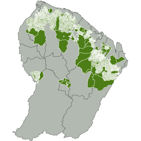
Découpage en unité de gestion des forêts du DFP et de Maripasoula, Papaïchton, Saül et Grand Santi, se basant principalement sur des limites physiques naturelles facilement identifiables sur le terrain (criques et crêtes), sauf parfois en limite de DFP.
-
Contour des Réserves Biologiques Intégrales et Dirigées (RBI et RBD), statut de protection de l'ONF. Publiées par arrêté ministériel. L'objectif de la RBI est la libre expression des processus d'évolution naturelle d'écosystèmes forestiers, à des fins de préservation de la diversité biologique, de protection d'habitats et d'espèces remarquables, et de développement des connaissances scientifiques. Une réserve biologique dirigée ou intégrale fait partie des espaces naturels protégés (ENP) qui sont des zones désignées ou gérées dans un cadre international, communautaire, national ou local en vue d'atteindre des objectifs spécifiques de conservation du patrimoine naturel. Une réserve biologique dirigée est un espace protégé en milieu forestier, ou en milieu associé à la forêt (landes, mares, tourbières, dunes), dans lequel une gestion conservatoire visant la protection d'espèces et d'habitats remarquables ou menacés est mise en place. Une réserve biologique intégrale est un espace protégé en milieu forestier, ou en milieu associé à la forêt (landes, mares, tourbières, dunes), laissé en libre évolution pour y étudier la dynamique spontanée des écosystèmes. Ces statuts s'appliquent aux forêts gérées par l'Office National des Forêts. Les réserves biologiques font partie des espaces relevant prioritairement de la Stratégie de Création d'Aires Protégées. Elles relèvent de la catégorie IV de l'UICN. Références légales : Conventions générales État-ONF du 3 février 1981 (sur les réserves biologiques en forêts domaniales) et du 14 mai 1986 (autres forêts relevant du régime forestier). Instruction n° 98-T-37 du 30 décembre 1998 sur les réserves biologiques intégrales (RBI). Instruction n° 95-T-32 de l'Office national des forêts du 10 mai 1995 sur les réserves biologiques dirigées (RBD).
-
Contour de la Réserve Biologique Intégrale Petites Montagnes Tortue, statut de protection de l'ONF. Publié par arrêté ministériel du 30 septembre 2016. Surface de 2364 ha en forêts domaniales de Bélizon et Régina. L'objectif de la RBI est la libre expression des processus d'évolution naturelle d'écosystèmes forestiers, à des fins de préservation de la diversité biologique, de protection d'habitats et d'espèces remarquables, et de développement des connaissances scientifiques.
-

Information layer containing the SAR Zones (Search and Rescue). This layer contains a description of the French search and rescue (SAR) areas and the location of the associated Maritime Rescue Coordination Center (MRCC). it covers the areas of responsibility of France. The layer was produced by the Shom pursuant to the Circular Circular of the International Maritime Organization (IMO No. SAR.8 / Circ.4 of 1 December 2012).
-
French Ministry of Culture / DRASSM – Shom The product "Limit of preventive archeology licence fee" contains the limits for the preventive archeology licence fee (1 nautical mile) as defined in the French Heritage Code. This limit is managed by the Department of Underwater Archeological Research (DRASSM) of the Ministry of Culture. This limit, defined by the Heritage Code at 1 nautical mile from the low-water line, permits to delineate the areas where the licence fee for preventive archeology at sea is applied. In Mainland France in the Gironde estuary, the limit for the preventive archeology licence fee is stopped by the crosswise limit of the sea as defined by the decree of 26 August 1857. In French Guiana, the limit for the preventive archeology licence fee is stopped in Maroni and Oyapock rivers by the crosswise limits of the sea respectively defined the order of 30 January 1991 and the order No 863 of 26 May 1986, until meeting the land boundary which delineates the rivers with the neighbouring States. The product "Limit of preventive archeology licence fee" is to use in addition to the digital product “Maritime Limits and Boundaries” of Shom (French: “Délimitations maritimes”) which represents the limits of the French maritime spaces of sovereignty or jurisdiction through the World. The product “Maritime Limits and Boundaries” (French: “Délimitations maritimes”) can be viewed on data.shom.fr (Maritime boundaries Category) and downloaded on the French national portal of maritime limits (https://maritimelimits.gouv.fr).
-
French Ministry of Agriculture and Food / DRASSM - Shom<br /> The product "Limits related to fishery uses" contains the limits related to fishery uses as defined in the French or European legislations. Those limits are managed by the Directorate for Sea Fisheries and Aquaculture (DPMA) of the Ministry of Agriculture and Food. <br /> Those limits are divided into three categories : <br /> - the inner limit of the coastal waters (6 nautical miles) ; <br /> - the 3-nautical-mile limit ; <br /> - the limit of fisheries for overseas territories (100 nautical miles).<br /><br /> The product "Limits related to fishery uses" is to use in addition to the digital product “Maritime Limits and Boundaries” of Shom (French: “Délimitations maritimes”) which represents the limits of the French maritime spaces of sovereignty or jurisdiction through the World.<br /> The product “Maritime Limits and Boundaries” (French: “Délimitations maritimes”) can be viewed and downloaded on the French national portal of maritime limits (https://maritimelimits.gouv.fr).
-
Ce service permet le téléchargement des données et services produits par la plateforme GéoGuyane