Cartographie SDOM
Cartographie interactive sur l'ensemble des zonages du SDOM.
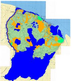
Le schéma départemental d'orientation minière (SDOM) de la Guyane a pour vocation de définir les conditions générales applicables à la recherche minière ainsi que les modalités de l'implantation et de l'exploitation des sites miniers. Il définit un zonage des secteurs ouverts et interdits à l'activité minière et fixe au besoin des contraintes particulières sur certaines zones.
Simple
Identification info
- Contains Operations
-
Operation Name Distributed Computing Platforms Connect Point Accès à la métadonnée de service WMS
Web services https://catalogue.geoguyane.fr/geonetwork/srv/fre/catalog.search#/metadata/024631df-f40f-4870-8e13-baadf866d1fe Accès à la carte PDF
Web services Accès à la carte interactive
Web services https://catalogue.geoguyane.fr/geosource/consultation?id=66035897
- Date (Creation)
- 2021-06-24T00:00:00
- Citation identifier
- https://catalogue.geoguyane.fr/geonetwork/srv/638a0faa-0d41-495b-a7d3-44fdfd923149
- Point of contact
-
Organisation name Individual name Electronic mail address Role DGTM Guyane
Chef de l'unité énergie et risques naturels
Point of contact
-
Régions de France
-
-
GUYANE
-
-
INSPIRE Service taxonomy
-
-
infoMapAccessService
-
-
OPENDATA
-
-
open data
-
données ouvertes
-
- Keywords
-
- Use limitation
-
Utilisation libre sous réserve de mentionner la source (DGTM) et la date de sa dernière mise à jour
- Access constraints
- Other restrictions
- Other constraints
-
Pas de restriction d’accès publique
- Service Type
- invoke
- Description
-
Guyane,
))
- Coupling Type
- Tight
- Coupled Resource
-
Operation Name Scoped name Identifier GetCapabilities
zone_2_s_973 125ffae0-53a5-431e-9568-5213b6643608
GetCapabilities
zone_0_s_973 cacbd740-dbb1-421e-af2d-96c9f0bd9a6d
GetCapabilities
zone_0_potentielle_ b6bc9b5d-fe7f-4fde-9d75-f512e5a33374
GetCapabilities
zone_1_s_973 c224cfbe-e24e-418b-ad3f-44c07ee19862
- OnLine resource
-
Protocol Linkage Name WWW:LINK-1.0-http--link
https://catalogue.geoguyane.fr/geonetwork/srv/fre/catalog.search#/metadata/024631df-f40f-4870-8e13-baadf866d1fe Accès à la métadonnée de service
WWW:LINK-1.0-http--link
https://catalogue.geoguyane.fr/geosource/consultation?id=66035897 Accès à la carte
- Units of distribution
-
liens associés
- Hierarchy level
- Map
- Other
-
carte
Conformance result
- Date (Publication)
- 2019-09-06T00:00:00
- Explanation
-
Cf.la spécification citée
- Pass
- Yes
- Statement
-
La cartographie du SDOM est une compilation de différents espaces tel que défini dans le document du SDOM. Il n'existe pas en tant que tel de zonage unique correspondant au SDOM.
Metadata
- File identifier
- 638a0faa-0d41-495b-a7d3-44fdfd923149 XML
- Metadata language
-
fre
- Character set
- UTF8
- Hierarchy level
- Service
- Hierarchy level name
-
service
- Date stamp
- 2024-07-23T09:20:14
- Metadata standard name
-
ISO 19115:2003/19139
- Metadata standard version
-
1.0
- Metadata author
-
Organisation name Individual name Electronic mail address Role DGTM Guyane
Administrateur de données localisées
Point of contact
Overviews
Spatial extent
Provided by
