Suivi des déforestations sur la zone littorale 2018
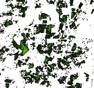
Suivi de la déforestation de janvier à décembre 2018 sur la zone littorale. cette étude a été réalisé localement par télédédection satellitaire radar du programme Sentinel 1 insensible à la couverture nuageuse. Sa précision est de 80 are. Par déforestation entendre la perte de couverture chlorophyllienne (plantation, forêt, culture). Croiser cette donnée avec le masque forêt pour identifier la perte de la forêt.
Simple
- Date (Creation)
- 2018-08-01T12:00:00
- Date (Publication)
- 2018-10-26T12:00:00
- Date (Revision)
- 2019-03-28T20:58:19
- Citation identifier
- https://catalogue.geoguyane.fr/geonetwork/srv/deb196cc-7297-4c5d-893e-3de8c5343869
- Point of contact
-
Organisation name Individual name Electronic mail address Role DAAF Guyane
SIG-DAAF
Point of contact
-
OPENDATA
-
-
données ouvertes
-
open data
-
-
Régions de France
-
-
GUYANE
-
-
GEMET - INSPIRE themes, version 1.0
-
-
Occupation des terres
-
Usage des sols
-
-
theme.prodige.rdf
-
-
OCCUPATION_SOL
-
FONCIER_AGRICOLE
-
FORET
-
- Keyword
-
OCCUPATION_SOL
- Keyword
-
TRANSFORMATION
- Keyword
-
VEGETATION
- Keyword
-
DAAF
- Keyword
-
GEOGUYANE
- Type
- Theme
- Date (Publication)
- 2023-11-08
- Keyword
-
OCCUPATION_SOL
- Keyword
-
TRANSFORMATION
- Keyword
-
VEGETATION
- Keyword
-
DAAF
- Keyword
-
GRAND_PUBLIC
- Type
- Theme
- Date (Publication)
- 2023-11-08
- Keyword
-
GRAND_PUBLIC
- Keyword
-
TRANSFORMATION
- Keyword
-
VEGETATION
- Keyword
-
OCCUPATION_SOL
- Keyword
-
DAAF
- Type
- Theme
- Date (Publication)
- 2023-11-08
- Use limitation
-
Données ouvertes
- Access constraints
- Other restrictions
- Other constraints
-
Pas de restriction d'accès publique
- Spatial representation type
- Vector
- Denominator
- 10000
- Language
-
fre
- Character set
- UTF8
- Topic category
-
- Location
- Description
-
Guyane française
))
- Begin date
- 2018-01-02T12:00:00
- End date
- 2018-12-31T12:00:00
- Reference system identifier
- EPSG / RGFG95 / UTM zone 22N (EPSG:2972) / 8.6
- Distribution format
-
Name Version ESRI Shapefile
1.0
OnLine resource
- Hierarchy level
- Dataset
Conformance result
- Date (Publication)
- 2019-03-27T12:00:00
- Explanation
-
cf. la spécification citée
- Pass
- Yes
- Statement
-
Télédétection radar sentinel 1
Metadata
- File identifier
- deb196cc-7297-4c5d-893e-3de8c5343869 XML
- Metadata language
-
fre
- Character set
- UTF8
- Hierarchy level
- Dataset
- Date stamp
- 2019-03-29T12:33:35
- Metadata standard name
-
ISO 19115:2003/19139
- Metadata standard version
-
1.0
- Metadata author
-
Organisation name Individual name Electronic mail address Role DAAF Guyane
SIG-DAAF
Point of contact
Overviews
Spatial extent
Provided by
