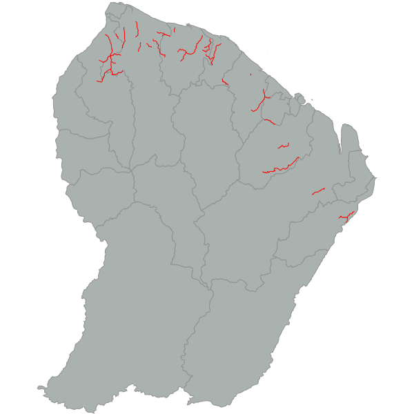
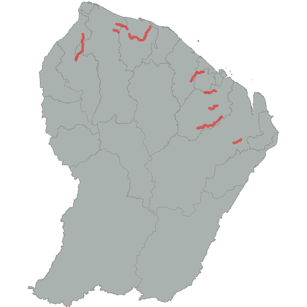
Principales pistes forestières
Les principales pistes (PP) forestières sont gérées par l'ONF et se situent principalement dans le domaine forestier permanent. La table attributaire comprend des informations sur la date de création de chaque piste, leur praticabilité ainsi que sur le statut juridique de la voie. Pour rappel toutes les pistes gérées par l'ONF sont interdites à la circulation publique.
Simple
- Date (Revision)
- 2024-06-24T14:02:02
- Date (Publication)
- 2012-02-16T10:02:00
- Citation identifier
- https://catalogue.geoguyane.fr/geonetwork/srv/7dcb76f2-8a77-4153-afbc-67fddf29bd43
- Point of contact
-
Organisation name Individual name Electronic mail address Role ONF Guyane
Pôle SIG
Point of contact
-
Régions de France
-
-
GUYANE
-
-
GEMET - INSPIRE themes, version 1.0
-
-
Réseaux de transport
-
- Keywords
-
- Use limitation
-
Utilisation libre sous réserve de mentionner la source (NOM DU SERVICE) et la date de sa dernière mise à jour (ANNEE DE MAJ)
- Access constraints
- Copyright
- Use constraints
- Copyright
- Spatial representation type
- Vector
- Denominator
- 100000
- Language
-
fre
- Character set
- UTF8
- Topic category
-
- Transportation
- Description
-
Guyane entière
))
- Reference system identifier
- EPSG / RGFG95 / UTM zone 22N (EPSG:2972) / 7.9
- Distribution format
-
Name Version ESRI Shapefile
1.0
- OnLine resource
-
Protocol Linkage Name OGC:WMS-1.1.1-http-get-map
https://datacarto.geoguyane.fr/wms? pistes_principalesonf
OGC:WFS-1.0.0-http-get-capabilities
https://datacarto.geoguyane.fr/wfs? pistes_principalesonf
WWW:LINK-1.0-http--link
https://catalogue.geoguyane.fr/rss/atomfeed/atomdataset/7dcb76f2-8a77-4153-afbc-67fddf29bd43 Accès au lien ATOM de téléchargement
OGC:WFS-1.0.0-http-get-capabilities
https://datacarto.geoguyane.fr/wfs?service=WFS&request=GetCapabilities pistes_principalesonf
OGC:WFS-1.0.0-http-get-capabilities
https://datacarto.geoguyane.fr/wfs/a02167aa-adcd-4cdb-b47e-e66ce768e61e?service=WFS&request=GetCapabilities pistes_principalesonf
WWW:DOWNLOAD-1.0-http--download
https://telechargement.geoguyane.fr/download/7dcb76f2-8a77-4153-afbc-67fddf29bd43 Accès au téléchargement des données
WWW:LINK-1.0-http--link
https://catalogue.geoguyane.fr/geosource/consultationWMS?IDT=52179 Accès à la visualisation des données
- Hierarchy level
- Dataset
Conformance result
- Date (Publication)
- 2010-10-19
- Explanation
-
cf. la spécification citée
- Pass
- Yes
- Statement
-
Cette donnée a été produite de différentes manières. Il s'agit dans certains cas de relevés GPS, de numérisations à l'aide de la BD TOPO IGN 2014, ou des mosaïques de la CTG (SPOT 6-7, PLEIADES, 2014-2015). Certains champs sont incomplets par manque d'information.
Metadata
- File identifier
- 7dcb76f2-8a77-4153-afbc-67fddf29bd43 XML
- Metadata language
-
fre
- Character set
- UTF8
- Hierarchy level
- Dataset
- Date stamp
- 2024-06-24T08:02:02
- Metadata standard name
-
ISO 19115:2003/19139
- Metadata standard version
-
1.0
- Metadata author
-
Organisation name Individual name Electronic mail address Role ONF Guyane
Pôle SIG
Point of contact
Overviews
Spatial extent
Provided by
