 GéoGuyane
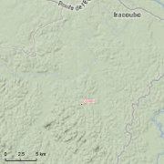
Guyadiv Counami: plots of forest inventory since 2000.
Guyadiv is a network of permanent forest plots installed in French Guiana. The site of Guyadiv in Counami is composed of 19 1200sq.m-plots. A complete inventory has been made on these plots, during 3 inventory sessions in 2000, 2001 and 2002. 1743 trees have been inventoried, with 92,2% to 100% of trees identified to species level. We only have the point coordinates and not the precise demarcation of the sample plots. In order to calculate the bounding box for these plots, we have expanded the point location 500 meters in each direction.
Simple
- Date (Creation)
- 2000-01-01
- Date
- 2001-01-01
- Date
- 2002-01-01
- Citation identifier
- CEBA_Guyadiv_Counami
- Credit
-
Prévost, Marie-Françoise
- Status
- Planned
- Point of contact
-
Organisation name Individual name Electronic mail address Role Institut de recherche pour le développement (IRD)
Sabatier, Daniel
Point of contact Centre national de la recherche scientifique (CNRS)
Freycon, Vincent
Point of contact Institut de recherche pour le développement (IRD)
Pelissier, Raphaël
Point of contact
- Maintenance and update frequency
- Irregular
-
GEMET - INSPIRE themes, version 1.0 INSPIRE themes
-
-
Environmental monitoring facilities
-
-
Geounits
-
-
Americas
-
South America
-
France
-
French Guiana
-
-
GEMET - Concepts, version 2.4
-
-
biodiversity
-
forest conservation
-
forest ecosystem
-
tropical forest
-
tropical forest ecosystem
-
primary forest
-
natural forest
-
inventory of forest damage
-
forest resource assessment
-
- Keywords
-
-
local coverage
-
labex CEBA
-
dispositifs forestiers GUYADIV
-
portail Ca-SIF
-
- Theme
-
-
sampling plots
-
mesoscale plot network
-
forest structure
-
tropical forest types
-
forest composition
-
permanent plots
-
diameter measurements
-
tree community
-
tree flora
-
- Place
-
-
Counami
-
- Use limitation
-
Please get in touch with a point of contact.
- Access constraints
- Other restrictions
- Other constraints
-
Agreement between potential user and point of contact.
- Classification
- Unclassified
- Spatial representation type
- Text, table
- Denominator
- 5000
- Language
-
eng
- Character set
- UTF8
- Topic category
-
- Biota
))
- Begin date
- 2000-01-01
- Reference system identifier
- EPSG / WGS 84 (EPSG:4326) / 7.9
- Distribution format
-
Name Version Shapefile
10.1
- Hierarchy level
- Dataset
- Statement
-
Under development.
Metadata
- File identifier
- 7729da18-b625-4e6e-a4c7-b76385d58108 XML
- Metadata language
-
eng
- Character set
- UTF8
- Hierarchy level
- Dataset
- Date stamp
- 2016-02-12T12:25:30
- Metadata standard name
-
ISO 19115:2003/19139
- Metadata standard version
-
1.0
- Metadata author
-
Organisation name Individual name Electronic mail address Role Institut de recherche pour le développement (IRD)
Sabatier, Daniel
Point of contact Centre national de la recherche scientifique (CNRS)
Freycon, Vincent
Point of contact Institut de recherche pour le développement (IRD)
Pelissier, Raphaël
Point of contact Institut de recherche pour le développement (IRD)
AMAP géoportail
Point of contact
Overviews

Spatial extent
Provided by
