Emprises acquisitions LIDAR dans le Sud de la Guyane
Emprises des acquisitions LIDAR effectuées par la société ALTOA dans le cadre du projet DYNFORDIV. Ce projet cherche à analyser les structure forestière de Guyane, il est porté par l'IRD en partenariat avec le Parc amazonien de Guyane, l'ONF, et l'AMAP.
Ces emprises représentes 2 acquisitions:
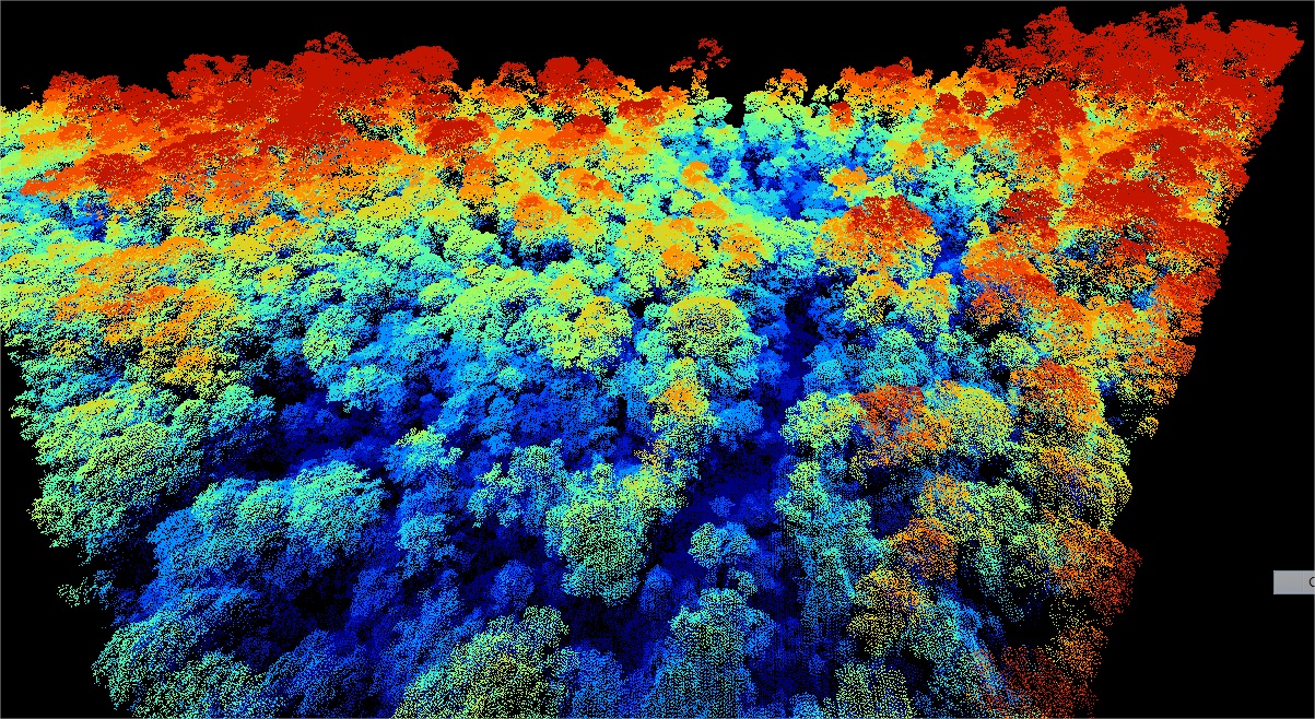
- La montagne Bellevue de l'Inini : 04/08/2014 - Western transect point density: all returns 17.05 last only 9.83 (per square units). Eastern transect point density: all returns 16.83 last only 10.28 (per square units). Lidar Riegl LMS Q560 onboard a plane operated by Altoa, swath angle +/-20deg
- Le mont Itoupé : 07-08/08/2014 - (total covered area = 72 km²). Based on sample tiles (45, 70,192, 201, 256), the mean emitted pulse density is ~12/m², and the mean echo density ~ 19/m². Lidar Riegl LMS Q560 aboard a plane operated by Altoa
Simple
- Date (Revision)
- 2015-08-10T15:07:00
- Date (Publication)
- 2015-01-10T00:00:00
- Citation identifier
- https://catalogue.geoguyane.fr/geonetwork/srv/52ba2e7e-17a2-4845-8c05-93ecbe3fd483
- Point of contact
-
Organisation name Individual name Electronic mail address Role Institut de recherche pour le développement (IRD)
Vincent, Gregoire
Point of contact PAG - Parc amazonien de Guyane
Point of contact
-
Régions de France
-
-
GUYANE
-
-
GEMET - INSPIRE themes, version 1.0
-
-
Altitude
-
- Keyword
-
PAG
- Keyword
-
TOPOGRAPHIE
- Keyword
-
RECHERCHE
- Keyword
-
VEGETATION
- Keyword
-
GRAND_PUBLIC
- Type
- Theme
- Date (Publication)
- 2023-11-08
- Use limitation
-
Utilisation libre sous réserve du PAG ou de l'IRD
- Access constraints
- Restricted
- Use constraints
- Copyright
- Classification
- Unclassified
- Spatial representation type
- Vector
- Denominator
- 1000
- Distance
- 0.25 m
- Language
-
fre
- Character set
- UTF8
- Topic category
-
- Imagery base maps earth cover
- Description
-
Guyane française
))
- Reference system identifier
- EPSG / RGFG95 / UTM zone 22N (EPSG:2972) / 7.9
- Distribution format
-
Name Version ZIP
{{format_version}}
- OnLine resource
-
Protocol Linkage Name OGC:WFS-1.0.0-http-get-capabilities
https://datacarto.geoguyane.fr/wfs? EmprisesacquisitionsLIDARdansl
WWW:LINK-1.0-http--link
https://catalogue.geoguyane.fr/rss/atomfeed/atomdataset/52ba2e7e-17a2-4845-8c05-93ecbe3fd483 Accès au lien ATOM de téléchargement
WWW:DOWNLOAD-1.0-http--download
https://telechargement.geoguyane.fr/download/52ba2e7e-17a2-4845-8c05-93ecbe3fd483 Accès au téléchargement des données
WWW:LINK-1.0-http--link
https://catalogue.geoguyane.fr/geosource/consultationWMS?IDT=92316 Accès à la visualisation des données
- Hierarchy level
- Dataset
Conformance result
- Date (Publication)
- 2010-11-21
- Explanation
-
cf. la spécification citée
- Pass
- Yes
- Statement
-
1. Toutes les données ont été acquises par Altoa lors de vol à altitude d'environ 600 mètres au-dessus du niveau du sol. Le système embarqué est composé d'un altimètre laser de balayage avec un mécanisme de miroir rotatif (Riegl LMS-Q560).
La longueur d'onde utilisée était 1550 nm. L'angle de balayage était d'environ +/- 20 °.
Le laser enregistre jusqu'à 5 impulsions réfléchies avec une précision nominale de 10cm.
La densité de point moyen est de 17 points / m².
ALTOA a également fournie le DTM et les point de terrain.
Données fournis en LAS, MNT, MNS, MNE... Voir points de contact.
Metadata
- File identifier
- 52ba2e7e-17a2-4845-8c05-93ecbe3fd483 XML
- Metadata language
-
fre
- Character set
- UTF8
- Hierarchy level
- Dataset
- Date stamp
- 2016-04-06T16:29:06
- Metadata standard name
-
ISO 19115:2003/19139
- Metadata standard version
-
1.0
- Metadata author
-
Organisation name Individual name Electronic mail address Role PAG - Parc amazonien de Guyane
Perbet Pauline
Point of contact
Overviews
Spatial extent
Provided by
