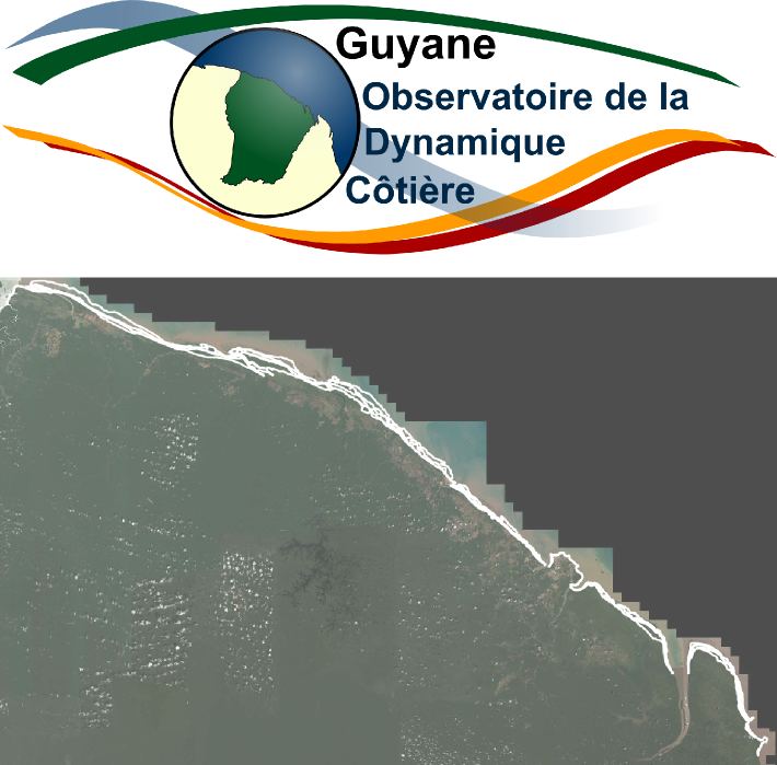
ODyC Guyane, localisation des sites suivis
Localisation des sites suivis par l'Observatoire de la Dynamique Côtière de Guyane depuis 2014 : Ile de Cayenne, Macouria (depuis 2018), Kourou et Awala-Yalimapo.
Simple
- Date (Revision)
- 2018-09-04T14:31:34
- Date (Publication)
- 2018-08-22T00:00:00
- Date (Creation)
- 2018-08-22T00:00:00
- Citation identifier
- https://catalogue.geoguyane.fr/geonetwork/srv/41e32cc3-f82e-447d-92da-b7423fc287e8
- Point of contact
-
Organisation name Individual name Electronic mail address Role DEAL Guyane
Chargé(e) de missions, Observatoire de la Dynamique Côtière de Guyane
Point of contact
-
Régions de France
-
-
GUYANE
-
-
GEMET - INSPIRE themes, version 1.0
-
-
Dénominations géographiques
-
-
OPENDATA
-
-
données ouvertes
-
open data
-
- Place
-
-
guyane
-
- Theme
-
-
sites suivis
-
- Theme
-
-
littoral
-
-
Domaines
-
-
AUTRES_ACTIVITES
-
BRGM
-
GRAND_PUBLIC
-
-
Domaines
-
-
AUTRES_ACTIVITES
-
GRAND_PUBLIC
-
-
Domaines
-
-
AUTRES_ACTIVITES
-
-
Domaines
-
-
AUTRES_ACTIVITES
-
-
Domaines
-
-
AUTRES_ACTIVITES
-
- Keywords
-
- Use limitation
-
Utilisation libre sous réserve de mentionner la source (DEAL Guyane) et la date de sa dernière mise à jour (2016)
- Access constraints
- Other restrictions
- Use constraints
- Copyright
- Other constraints
-
Licence Ouverte 1.0 http://www.data.gouv.fr/Licence-Ouverte-Open-Licence .
- Classification
- Unclassified
- Spatial representation type
- Vector
- Denominator
- 1000
- Language
-
fre
- Character set
- UTF8
- Topic category
-
- Oceans
- Description
-
Guyane, Littoral
))
- Begin date
- 2018-08-30T00:00:00
- Reference system identifier
- EPSG / RGFG95 / UTM zone 22N (EPSG:2972) / 7.9
- Distribution format
-
Name Version ZIP
V1
ESRI Shapefile
1.0
- OnLine resource
-
Protocol Linkage Name OGC:WMS-1.1.1-http-get-map
https://datacarto.geoguyane.fr/wms? sitessuivis
OGC:WFS-1.0.0-http-get-capabilities
https://datacarto.geoguyane.fr/wfs? sitessuivis
WWW:LINK-1.0-http--link
https://catalogue.geoguyane.fr/rss/atomfeed/atomdataset/41e32cc3-f82e-447d-92da-b7423fc287e8 Accès au lien ATOM de téléchargement
OGC:WMS-1.1.1-http-get-map
https://datacarto.geoguyane.fr/wms? sites_suivis
OGC:WFS-1.0.0-http-get-capabilities
https://datacarto.geoguyane.fr/wfs? sites_suivis
WWW:DOWNLOAD-1.0-http--download
https://telechargement.geoguyane.fr/download/41e32cc3-f82e-447d-92da-b7423fc287e8 Accès au téléchargement des données
WWW:LINK-1.0-http--link
https://catalogue.geoguyane.fr/geosource/consultationWMS?IDT=52613297 Accès à la visualisation des données
- Hierarchy level
- Dataset
Conformance result
- Date (Publication)
- 2010-10-11T00:00:00
- Explanation
-
cf. la spécification citée
- Pass
- Yes
- Statement
-
Localisation des sites suivis par l'Observatoire de la Dynamique Côtière de Guyane depuis 2014 : Ile de Cayenne, Macouria (depuis 2018), Kourou et Awala-Yalimapo.
Metadata
- File identifier
- 41e32cc3-f82e-447d-92da-b7423fc287e8 XML
- Metadata language
-
fre
- Character set
- UTF8
- Hierarchy level
- Dataset
- Hierarchy level name
-
ensemble
- Date stamp
- 2022-06-01T11:53:04
- Metadata standard name
-
ISO 19115:2003/19139
- Metadata standard version
-
1.0
- Metadata author
-
Organisation name Individual name Electronic mail address Role DEAL Guyane
Chargé(e) de missions, Observatoire de la Dynamique Côtière de Guyane
Point of contact
Overviews
Spatial extent
Provided by
