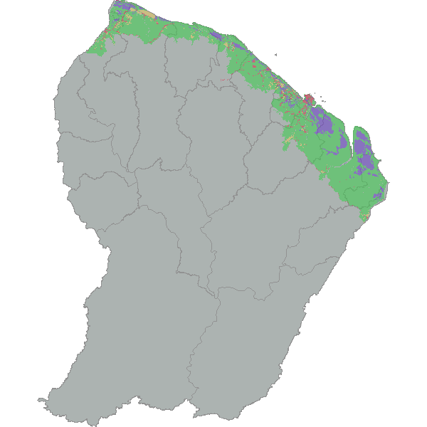
Occupation du sol 2008
Occupation du sol sur la bande littorale en 2008
Simple
- Date (Revision)
- 2011-11-21T00:00:00
- Date (Publication)
- 2011-08-08T22:54:00
- Citation identifier
- https://catalogue.geoguyane.fr/geonetwork/srv/1a024529-e63a-4c56-84a6-d5db1da83b0b
- Point of contact
-
Organisation name Individual name Electronic mail address Role ONF Guyane
Pôle SIG
Point of contact
-
Régions de France
-
-
GUYANE
-
-
Domaines
-
-
GRAND_PUBLIC
-
OCCUPATION_SOL
-
ONF
-
-
GEMET - INSPIRE themes, version 1.0
-
-
Occupation des terres
-
- Use limitation
-
Utilisation libre sous réserve de mentionner la source (a minima le nom du producteur) et la date de sa dernière mise à jour
- Access constraints
- Copyright
- Use constraints
- Copyright
- Spatial representation type
- Vector
- Denominator
- 100000
- Language
-
fre
- Character set
- UTF8
- Topic category
-
- Environment
- Description
-
Guyane
))
- Reference system identifier
- EPSG / RGFG95 / UTM zone 22N (EPSG:2972) / 7.9
- Distribution format
-
Name Version ESRI Shapefile
1.0
- OnLine resource
-
Protocol Linkage Name WWW:DOWNLOAD-1.0-http--download
https://catalogue.geoguyane.fr/geonetwork/srv/fre/resources.get?uuid=1a024529-e63a-4c56-84a6-d5db1da83b0b&fname=nomenclature.xls&access=private nomenclature.xls WWW:LINK-1.0-http--link
https://catalogue.geoguyane.fr/rss/atomfeed/atomdataset/1a024529-e63a-4c56-84a6-d5db1da83b0b Accès au lien ATOM de téléchargement
WWW:DOWNLOAD-1.0-http--download
https://telechargement.geoguyane.fr/download/1a024529-e63a-4c56-84a6-d5db1da83b0b Accès au téléchargement des données
WWW:LINK-1.0-http--link
https://catalogue.geoguyane.fr/geosource/consultationWMS?IDT=15149 Accès à la visualisation des données
- Hierarchy level
- Dataset
Conformance result
- Date (Publication)
- 2010-10-19
- Explanation
-
Cf. Spécification pré-citées
- Pass
- Yes
- Statement
-
Pour la mise à jour 2008, la photo-interpretation repose principalement sur les images SPOT accessibles grâce au dispositif SEAS
La cartographie de 2008 étant une « mise à jour », sa numérisation s’est appuyée sur la couche d’occupation du sol de 2005.
La cartographie a été réalisée par photo-interprétation puis numérisation des zones identifiées.
Metadata
- File identifier
- 1a024529-e63a-4c56-84a6-d5db1da83b0b XML
- Metadata language
-
fre
- Character set
- UTF8
- Hierarchy level
- Dataset
- Date stamp
- 2021-02-09T09:58:42
- Metadata standard name
-
ISO 19115:2003/19139
- Metadata standard version
-
1.0
- Metadata author
-
Organisation name Individual name Electronic mail address Role ONF
VERGER Gaëlle
Point of contact
Overviews
Spatial extent
Provided by
