Expertise foncière du littoral et des territoires isolés de Guyane 2005-2008-2011
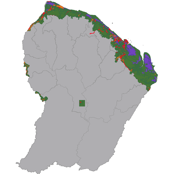
Occupation du sol du littoral et des territoires de Apatou, Grand Santi, Papaïchton, Maripasoula, Saül en 2005 2008 et 2011 par photo-interprétation de photos aériennes et d'images satellite
Simple
- Date (Revision)
- 2014-02-21T15:11:00
- Date (Publication)
- 2014-02-06T12:23:00
- Citation identifier
- https://catalogue.geoguyane.fr/geonetwork/srv/0f0fbe59-5d54-48eb-94ab-6bd9964e2c47
- Point of contact
-
Organisation name Individual name Electronic mail address Role ONF
VERGER Gaëlle
Author ONF Guyane
Pôle SIG
-
Régions de France
-
-
GUYANE
-
- Keyword
-
OCCUPATION_SOL
- Keyword
-
ZONAGES_AGRICOLE
- Keyword
-
ZONAGES_ETUDE
- Keyword
-
ONF
- Keyword
-
FONCIER_LITTORAL
- Keyword
-
GRAND_PUBLIC
- Type
- Theme
- Date (Publication)
- 2023-11-08
- Use limitation
-
Utilisation libre sous réserve de mentionner la source (NOM DU SERVICE) et la date de sa dernière mise à jour (ANNEE DE MAJ)
- Use constraints
- Copyright
- Other constraints
-
Pas de restriction d’accès public selon INSPIRE
- Classification
- Unclassified
- Spatial representation type
- Vector
- Denominator
- 5000
- Language
-
fre
- Character set
- UTF8
- Topic category
-
- Imagery base maps earth cover
- Description
-
Guyane française
N
S
E
W
))
- Reference system identifier
- EPSG / RGFG95 / UTM zone 22N (EPSG:2972) / 7.9
- Distribution format
-
Name Version ZIP
- OnLine resource
- Hierarchy level
- Dataset
- Statement
-
A COMPLETER
Metadata
- File identifier
- 0f0fbe59-5d54-48eb-94ab-6bd9964e2c47 XML
- Metadata language
-
fre
- Character set
- UTF8
- Hierarchy level
- Dataset
- Date stamp
- 2019-02-20T20:42:48
- Metadata standard name
-
ISO 19115:2003/19139
- Metadata standard version
-
1.0
- Metadata author
-
Organisation name Individual name Electronic mail address Role ONF
VERGER Gaëlle
Point of contact
Overviews
large_thumbnail
thumbnail
Spatial extent
N
S
E
W
Provided by

Associated resources
Not available