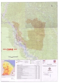
Classement des abattis et de la montagne Cottica
Plan de délimitation du site protégé.
Carte annexée à l'arrêté ministériel de classement à l'inventaire des sites et monuments naturels de Guyane (15/12/2011).
Simple
Identification info
- Date (Creation)
- 2011-01-15T00:00:00
- Citation identifier
- https://catalogue.geoguyane.fr/geonetwork/srv/019d3ff5-5437-482b-9440-f57c933f8896
- Status
- Completed
- Point of contact
-
Organisation name Individual name Electronic mail address Role DEAL Guyane
Chargée de mission sites et paysages
Point of contact
-
Régions de France
-
-
GUYANE
-
-
INSPIRE Service taxonomy
-
-
infoMapAccessService
-
-
INSPIRE inspires
-
-
Sites protégés
-
-
Domaines
-
-
ZONAGES_PAYSAGE
-
GRAND_PUBLIC
-
- Keywords
-
- Use limitation
-
Aucune condition ne s’applique
- Access constraints
- Copyright
- Use constraints
- Copyright
- Service Type
- invoke
- Description
-
Guyane, Commune de Papaïchton
N
S
E
W
))
- Coupled Resource
-
Operation Name Scoped name Identifier GetCapabilities
906ad9be-2e6f-4abf-85fc-417b9c698244
- Coupling Type
- Tight
- Contains Operations
-
Operation Name Distributed Computing Platforms Connect Point Accès à la carte
Web services https://catalogue.geoguyane.fr/geosource/consultation?id=91028
- Reference system identifier
- EPSG / RGFG95 / UTM zone 22N (EPSG:2972) / 7.9
- OnLine resource
-
Protocol Linkage Name WWW:LINK-1.0-http--link
https://catalogue.geoguyane.fr/geosource/consultation?id=91028 Accès à la carte
- Hierarchy level
- Service
- Statement
-
Carte éditée au 1/50000e à partir du SCAN 50 IGN (première édition)
Metadata
- File identifier
- 019d3ff5-5437-482b-9440-f57c933f8896 XML
- Metadata language
-
fre
- Character set
- UTF8
- Hierarchy level
- Service
- Hierarchy level name
-
service
- Date stamp
- 2020-07-23T15:08:12
- Metadata standard name
-
ISO 19115:2003/19139
- Metadata standard version
-
1.0
- Metadata author
-
Organisation name Individual name Electronic mail address Role DEAL Guyane
Chef de l'unité Information géographique et diffusion de la connaissance
Point of contact
Overviews
large_thumbnail
Spatial extent
N
S
E
W
Provided by

Associated resources
Not available